 MPS
partnered with Newport Collaborative Architects,
Inc. to provide GIS decision-making services
for the West Side Master Plan Task Force’s
West Side Planning Inventory.
MPS
partnered with Newport Collaborative Architects,
Inc. to provide GIS decision-making services
for the West Side Master Plan Task Force’s
West Side Planning Inventory.
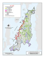
MPS conducted the Preferred Preservation
Mapping (PPM) project. All major social, environmental,
infrastructure capacities and constraints were
identified and integrated into the West Side
GIS database for the 7.2 sq mile area. Using
a GIS grid-based analysis, land uses and natural
resources were classified and rated in six resource
areas; water, agricultural and silvicultural,
coastal, recreation, cultural and historical,
and biodiversity. This PPM analysis supports
a variety of planning and development analyses.
For example, the identification of areas important
for preservation, those more suitable for development,
areas with the least impact upon a particular
resource or multiple resources, areas that could
take advantage of the resources and provide
opportunities for development scenarios upon
them. It also enables decision-makers to compare
and contrast the West Side Master Plan area
to other environmentally significant areas on
Aquidneck Island. A description of the PPM project,
methodology, results and maps summarizing the
level of importance of resources are available
at www.aquidneckplanning.org/westside
The
PPM project received First Place in the NEARC
2003 Map Poster Competition at the 18th Annual
North East ARC Users Group Conference, November
2003, Newport, RI.