 MPS
provides a range of GIS mapping and planning-related
consulting services for this non-profit land
conservation organization on Aquidneck Island.
MPS
provides a range of GIS mapping and planning-related
consulting services for this non-profit land
conservation organization on Aquidneck Island.
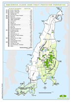
Conducted
the Aquidneck
Island Conservation Mapping Project,
a comprehensive island-wide GIS analyses of
over 25,000 parcels that established ALT's conservation
strategy. Publications, including island-wide
and town-specific maps were mailed by the Aquidneck
Land Trust to over 23,000 households in
Newport, Middletown and Portsmouth.
Other
GIS services have included technical support
for developing and implementing other land conservation
strategies, greenways and trails planning and
design. Mapping is prepared for local planning
board meetings, property baseline documentation,
grant applications, assorted promotional materials
and public informational workshops.