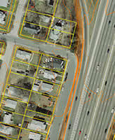
 MPS
partnered with Fuss & O'Neill, Inc. to undertake
a multi-year project to update and expand the
City of Cranston's present GIS system. The project
includes the development of 100' scale color
digital orthophotography (12" resolution),
planimetric and 2' topographic mapping, a 32,000
record parcel base and Citywide storm and sanitary
sewer collection system.
MPS
was engaged to provide independent Quality Assurance
and Quality Control (QA/QC) over the development
of the 32,000 record parcel mapping and all
photogrammetric vector and imagery deliverables
(over 18 GB of data). These consisted of true
color orthophotography, street centerlines,
edge of road pavement, hydrography, bridges,
datum grid, 2' contour lines and spot elevations
(on both the City and NVGD88 datums), and FGDC-compliant
metadata.
The City of Cranston
received the ESRI
Special Achievement in GIS Award 2002 for
this project, one of the region's most comprehensive
GIS development projects.