 MPS
is
the Town's lead GIS Consultant for an Enterprise-wide
GIS Implementation. Managed development of 100'-scale
planimetric, topographic and orthophoto mapping,
town-wide parcel mapping, and mapping of sewer
and storm drain collection systems. Coordinated
cataloguing, scanning and indexing of over 600
sewer drawings and plans.
MPS
is
the Town's lead GIS Consultant for an Enterprise-wide
GIS Implementation. Managed development of 100'-scale
planimetric, topographic and orthophoto mapping,
town-wide parcel mapping, and mapping of sewer
and storm drain collection systems. Coordinated
cataloguing, scanning and indexing of over 600
sewer drawings and plans.
 Provides
GIS training and support for all Town users,
facilitates GIS integration with VISION, MUNIS,
GEO and work-order applications.
Provides
GIS training and support for all Town users,
facilitates GIS integration with VISION, MUNIS,
GEO and work-order applications.
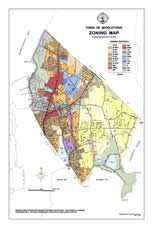
Conducted
CERCLIS risk assessment mapping, GASB-34 support,
GIS pavement management analyses, wellhead protection
plans, watershed-based land use studies, design
of sewer pumping stations, cell tower siting
and other planning analyses. Provided GIS mapping
support for Comprehensive Community Plan
2002 and 2006, the Award-Winning Town
Center Plan, Official Zoning Map, Assessor's
Maps and various zoning amendment and planning
board matters. Prepared content for www.middletownri.com